Class Location Intelligence
See where Class Location escalation may be developing
KartaSoft helps transmission pipeline operators maintain a consistent view of current Class Location, understand where consequential change may be developing, and evaluate that forward-looking view against known historical outcomes.
An application of KartaSoft’s Physics-Informed Operational Intelligence
Class Location changes as the world around the pipeline changes
Development does not occur on the same schedule as periodic Class Location assessments.
A Class Location assessment can be current when completed while development continues around the corridor.
New structures, land-use changes and construction activity accumulate between assessment cycles, while the information required to reassess them may sit across separate records, GIS layers and previous analyses.

Development signals indicate possibility, not certainty.
A permit may not become construction.
A new structure may not be sufficient to change classification.
Across a large network, the important distinction is which development signals could actually affect classification and therefore warrant earlier review.
This creates two connected operational challenges:
Keeping the current picture accurate
Information may sit across multiple datasets, systems and assessment cycles. As conditions change, teams must repeatedly bring that information together, recalculate classifications, and maintain a consistent history of what changed and when.
Understanding what may change next
Current-state determination answers an essential question:
What is the Class Location of this segment today?
It does not fully answer the planning question:
Which segments show the strongest evidence of potential escalation, and how much time may be available to evaluate the implications?
Keep Class Location current,
understand where changes may be developing
KartaSoft's solution for the challenge:
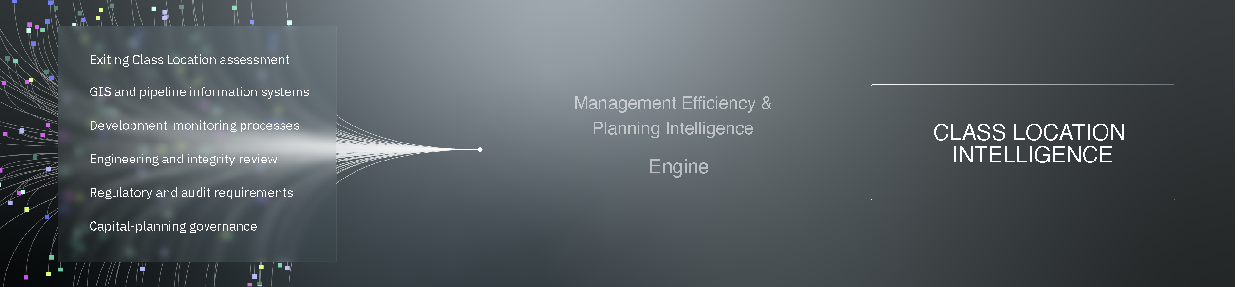
Current-State Management and Planning Intelligence
Management Efficiency
Class Location Intelligence brings relevant information into a consistent network-level record, supports repeatable current-state calculation, and maintains a clearer view of changing conditions over time.
This is designed to reduce dependence on repeatedly rebuilding analysis from fragmented information and to create a more consistent basis for review.
Current-State Management supports:
→ More consistent Class Location calculation
→ More repeatable reassessment as underlying information changes
→ A maintainable history of structures, development and classification conditions
→ Reduced recurring effort associated with fragmented analysis
→ A clearer basis for internal and regulatory review
Planning Intelligence
On the same information foundation, Class Location Intelligence creates a probability-scored view of where escalation may be developing across the network.
Each segment receives a comparative escalation probability, giving teams a common basis for ranking where closer review is most warranted and evaluating whether useful advance visibility exists.
Planning Intelligence supports:
→ Segment-level escalation probability
→ Network-wide comparison
→ Configurable planning horizons
→ Prioritization of segments warranting closer review
→ Historical evaluation of forecast performance
More efficient management.
More time to plan.
Management Efficiency
Reduce recurring Class Location workload
A consistent, maintainable network record reduces dependence on repeatedly rebuilding analysis from fragmented information.
Improve consistency across assessment cycles
The challenge has moved beyond understanding the state of aging assets into proving which investments should move first because they reduce the greatest operational, service, and regulatory risk.
Make changing conditions easier to understand
The challenge has moved beyond understanding the state of aging assets into proving which investments should move first because they reduce the greatest operational, service, and regulatory risk.
Planning Intelligence
Compare potential escalation across the network
![]()
Probability scoring creates a common basis for comparing development signals across the network and identifying the segments that warrant closer review.
Focus limited review capacity

Prioritization helps teams direct attention toward segments where potential escalation warrants closer examination.
Establish whether earlier visibility is achievable
![]()
Historical evaluation shows whether previous escalation would have been identified and whether the signal would have appeared early enough to support planning.
How It Works
Forward-Looking Planning Intelligence
1. Consolidate
Bring together relevant Class Location information, which may include structure records, development activity, pipeline context and historical assessments.
2. Compute
Calculate current Class Location across the relevant pipeline segments using a consistent and repeatable method.
Examine how structures, development and classification conditions have changed over time.
4. Forecast
Estimate the probability of individual segments escalating to a higher Class Location within a configurable time horizon.
5. Prioritize
Apply that view across the network to identify segments where potential escalation warrants closer engineering, integrity or planning review.
Back test the forecast against known outcomes
Forward-looking scores can be tested retrospectively against known Class Location outcomes to measure three things that matter operationally:
→ whether actual escalations would have been identified,
→ how much useful lead time may have existed,
→ the resulting false-positive burden.
Designed to complement existing workflows
Class Location Intelligence is not positioned as a replacement for existing Class Location, GIS, integrity or engineering processes.
Customers normally ask
No. Class Location Intelligence is designed to complement existing Class Location, integrity and engineering workflows with a consistent analytical and forward-looking layer.
No. Probability expresses comparative likelihood under the available information. Some segments with a higher score will not subsequently escalate.
Current-state tools help operators calculate, maintain and document Class Location. KartaSoft’s approach adds a probability-scored view of potential escalation and evaluates that view against known historical outcomes.
Development monitoring can identify new structures or changing land use. KartaSoft’s approach considers how observed change relates to the probability of Class Location escalation across individual pipeline segments.
The precise inputs depend on the operator’s available information and network context. Relevant sources may include structure records, development information, pipeline context and historical Class Location assessments.
No analytical approach eliminates the effects of incomplete or inconsistent information. KartaSoft evaluates the available data, makes relevant limitations visible and considers additional sources where they demonstrate measurable contribution.
Outputs can be tested retrospectively against known historical outcomes, including whether actual escalations would have been identified, achievable advance warning and false positives.
No. KartaSoft provides additional information for consideration by qualified customer personnel. Engineering judgment, regulatory obligations and established governance processes remain central.
Outputs are auditable, repeatable, and suitable for regulatory and internal review
Evaluate where earlier Class Location visibility could help
Review how your team maintains current Class Location, monitors development around the network, and evaluates potential escalation. We can explore whether your available historical information can support meaningful retrospective testing and earlier planning intelligence.
Protected Intellectual Property